Before the archaeologists put a shovel in the Nacoochee Mound in 1915, the man who owned it wanted one thing understood: if there was gold in there, it was his. Dr. L. G. Hardman, later governor of Georgia, let them dig "for a consideration mutually satisfactory," a phrase the team's report never explains. He had two conditions. The mound's form had to be restored afterward, and any precious metals found during the work "should be placed in the owner's hands."
That last clause tells you what people figured was in there. The belief was "prevalent in Georgia, even among educated people," the report says, "that hoards of gold are hidden beneath earthworks reared by Indians in ancient times." You can sort of see how they got there. This is gold rush country, and the valley had already produced one baffling surprise. In 1834, according to a letter in the Southern Banner of Athens that the Georgia Historical Society cites, miners digging a canal here hit a row of partly decayed cabins about eight feet underground, connected like 34 rooms and running about 300 feet. In a place where that can happen, treasure under a hill doesn't sound so crazy.
So the archaeologists wanted to know who was in there, the owner wanted first claim on anything shiny, and everybody was going to have to work around the gazebo.
A hill built by the basket
The mound is far older than anything on top of it. A Georgia Historical Society marker says the village here was occupied for more than 1,000 years, first by Muskogean-speaking people and later by the Cherokee, and that the builders raised the mound "one basket-load at a time over generations." University of Georgia students who tested the surrounding fields in 2004 put the main occupation at about 1350 to 1600. Most people lived on the flat ground around it. The top held something else. The excavators concluded it was the site of the town-house, and they found fire pits at old surface levels all through the earth. People had been using the top of this thing the whole time they were building it.
By the 1820s the valley was being farmed by settlers. An account of the Williams family, quoted in the 1918 report, says the father settled here "about the time the Indians were driven away" and taught his sons farming: "they ploughed up gunlocks, swords, broken shells, bullets, tomahawks, arrows, human bones and the like." The land had been ceded to the United States in the Cherokee treaty of 1819. When Charles C. Jones described the mound in 1873, its slopes and summit had been cultivated for years. "Tradition has preserved no memories of the people by whom it was erected," he wrote, "and its treasures, if any, are still concealed within its own bosom."
Jones had reason to wonder about those treasures. He'd been studying what Captain Nichols turned up.
Captain Nichols and his plow
James Nichols built the Italianate house next door in 1870. That June, by Jones's account, he was plowing near the mound when he struck large stone slabs several inches under the field, about 30 feet from its western slope. Under them were three stone graves. In the central one lay an old man more than six feet tall, stretched out at full length on a floor of river stones, with a copper axe near his shoulder that measured almost 10 inches. A big conch shell had been hollowed out, probably for a cup. Jones thought the copper came from Lake Superior and the shell from the Atlantic coast or the Gulf, which is a long way for an axe and a cup to come.
Nichols kept digging, and he kept what he found. The marker at the site quotes the Atlanta Constitution of January 4, 1891, on "a large cabinet" of relics, some of them "taken from Indian graves that surrounded the mound in front of Captain Nichol's residence." The article said every grave he opened added to the collection. By 1918 most of those objects were in the Museum of the American Indian. The copper axe was not. The report describes its whereabouts as "now unknown."
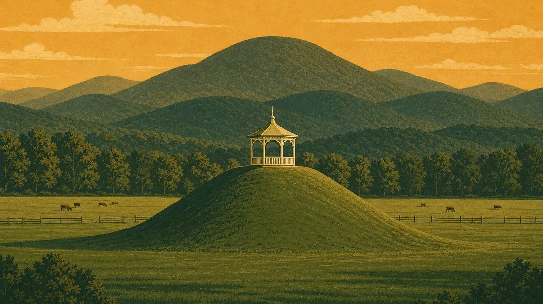
What Nichols did to the mound itself was stranger, in its way. The marker puts it plainly: he "did not excavate the entire mound; instead, he had planted it in flowers and added the summer house or gazebo seen today."
The pagoda
Why is there a gazebo on a burial mound? Landscaping. That's the entire answer, and we've looked.
The 1915 team heard from a mechanic who had worked on the structure, which the report in this one passage calls a pagoda. He told them about two feet of the summit had been removed for it twenty-seven years earlier. That would make it about 1888. Other accounts say 1890 or the 1890s, so we're sticking with the late 1800s. The sides were then dug back into a steep terrace and planted with vines and shrubbery. A garden went in on top, with water piped over from the house, and a fence went around the whole thing. The report adds one more detail about the leveling, and it doesn't linger: "Human bones are said to have been found in the process of removal, but of their character nothing is now known."
The leveling stopped just short of something else. When the team dug down years later, they found "an immense fire-pit, or series of fire-pits one above another," with its top six or seven inches under the surface. The charcoal of poles and canes nearby made them wonder whether it had held the sacred fire of the town-house. For about a generation, the summer house and its garden had shared that summit with it, half a foot of dirt between them.
Rain, and some boys
The expedition, a joint effort of the Museum of the American Indian and the Smithsonian's Bureau of American Ethnology, started on June 19, 1915. George Heye, F. W. Hodge and George Pepper took turns running it, and work went on until October 29.
They began at the top, removing four feet of soil, "excepting the middle part occupied by the summer-house." Then they took another four feet, and on down. Picture that for a second: a Victorian garden structure on a shrinking island of dirt while men cut layers away around it. We couldn't find out how long it stayed up there or when it came off.
The weather fought them. The report calls this an "unusually wet region" and blames "excessive rainfall" for the fact that they couldn't finish. One burial came to light only because a bank of the great eastern trench caved in after a heavy rain.
People were a problem too. Clearing the soil above one small stone grave near the bottom of the mound took a full day's work, so the team covered it with earth overnight. Then, the report says, "some boys visited the spot and in their play jumped on the grave from the bank above," which broke what was inside into pieces. What was inside was the only painted vessel from the whole dig. It was repaired, and the report pictures it. Pepper's 1917 account calls it a dog. The 1918 report says nobody knows what animal it's meant to be, then offers this: "The tail suggests an opossum and the head a wildcat."
Other finds tell you how long people were here. Deep in the mound, a copper axe lay on woven matting, and copper salts had kept part of its wooden handle from rotting away. One burial held 45 arrowpoints. Near the top were things that came from another world altogether: blue glass trade beads, metal buttons and a breast ornament of 410 shell and glass beads. At the northeastern base they picked up a Spanish coin dated 1808 with a neat hole punched near the top, so somebody had worn it. The report took that as a sign the place was still lived in during the early 1800s. The New Georgia Encyclopedia has the two Cherokee towns documented in this valley abandoned shortly after the mid-1700s. The coin isn't talking.
Seventy-five people
The team recorded 75 burials: 56 adults, seven adolescents, four children and eight people whose age they couldn't determine. According to Pepper's account, 11 of them lay in the top five feet or so, and the other 64 lay below, some more than 19 feet down. Of the burials whose position could be read, nearly all were flexed, and most of the dead had been laid with their heads toward the east. The wet ground had been at work for centuries. All of them, the report says, were "so greatly decayed as to be entirely beyond recovery."
Twenty-seven of the 75 had objects of "more or less importance" with them. The word gold shows up in the report only in the passage about the owner's clause and the local belief. No hoard appears anywhere in its pages. The museum kept the copper axe, so copper evidently didn't count as precious under the deal.
We don't know what any of these people called themselves. The report was confident they were Cherokee and called Nacoochee "a typical Cherokee earthwork." Later work splits that apart, and the state's own page now says the mound was probably in use long before the Cherokee. The burials near the top, the ones with the glass beads, are another matter: Pepper thought those levels were Cherokee, and the encyclopedia dates such burials to the 1600s. The report's authors also identified the site with Guaxule, the town that, by their account, gave De Soto's army 300 dogs for food in 1540. Hold off on that one, though. A later reconstruction of his route suggests the town of Guasili may have been near Embreeville, Tennessee.
Put it back
The team meant to take the whole mound apart. "Although it was the intention to excavate the mound completely," the report says, the rain made that impossible in a single season, "and a satisfactory concession for the resumption of the work in the following summer could not be obtained from the owner." It doesn't say why, and we'd love to know. (The New Georgia Encyclopedia says the mound was completely excavated. The people who dug it say they didn't finish, so we're going with them.)
Then came the other half of the deal. The mound was reconstructed, and according to the marker, "Nichols' summer house once again graced its summit." So the hill in the pasture is in the right spot, but the shape you see is the one the diggers put back, and they were copying a mound already altered by a plow and a garden. We couldn't find a record of how much of the inside was left alone. No more digging is planned, the marker says, and the state now protects the mound and the village site around it. Hardman's family gave the property to Georgia in 1999.
The part everybody tells you
Nacoochee, a Cherokee princess, loved Sautee, a warrior from an enemy people. Her father had him thrown off Yonah Mountain, she jumped after him, and the two were buried in the mound. You'll hear it within about a day of arriving.
"There have been as many versions of the legend of Nacoochee as there have been cows grazing the fields of that lush White County valley," wrote Johnny Vardeman, retired editor of the Gainesville Times. He turned up a version from the Southern Banner of June 1835, the same Athens paper that had carried the buried-cabins letter a year earlier. In that one her lover is Cushtaree, a rival named Wocklocknah throws a barbed hatchet, it ends in a knife fight, and nobody goes off a mountain. Vardeman says that version apparently doesn't even mean this mound. George White's collection of the 1850s, as James Mooney summed it up, has the couple killed while running from her angry father, and the mound raised over their single grave.
The people who knew the most had no patience for any of it. Mooney, the Smithsonian ethnographer who spent years collecting Cherokee stories, called White's version a "fictitious legend" and said the only grain of truth in it is that the name "has a slight resemblance" to the Cherokee word for star. The 1918 report went further, calling it a "ridiculous yarn" and adding that "the entire fabric of the story is imaginary." Then its authors admitted defeat, in terms close to what they'd said about the gold: the tale "has received such currency that no argument can dismiss it from the minds even of those otherwise intelligent."
They were right about that. Local author Emory Jones, who wrote a whole book on the mound and believed none of the versions, gets the last word in Vardeman's column: "Facts should never get in the way of a good story." So the two people whose names are all over this valley probably never existed. The 75 the diggers did find have no names anyone wrote down.
The cows
Georgia State Parks describes the "gazebo-topped mound and cow pasture" as a favorite north Georgia landmark, and the cows are there on purpose. According to a 2006 University of Georgia report, the state's Department of Natural Resources lets a herd graze the fields to keep up the pastoral look the valley is known for, as was the custom before the state took over.
That report is number 3508 in the university's archaeology catalog. Its title begins "Archaeological Investigations and Monitoring Installation of Cattle Feeding and Watering Facility." At the time, the abstract says, the herd was drinking straight out of a small stream near the highway. The plan was concrete troughs about 400 feet east of the mound. Even the cow trough in this valley gets an archaeological report.