
Indigenous Heritage of the Valley
Ten thousand years of human history in the mountains that surround Helen
Long before Helen became a Bavarian-themed tourist village, long before European settlers arrived in the Georgia mountains, and long before the Cherokee established their thriving civilization across the southern Appalachians, the Nacoochee Valley was home to some of the earliest human communities in what is now the southeastern United States. The valley where Helen sits today - at the headwaters of the Chattahoochee River, surrounded by the protective ridges of the Blue Ridge - has been continuously inhabited for at least ten thousand years, making it one of the most historically significant landscapes in Georgia.
Understanding this deep indigenous heritage enriches any visit to Helen. The mountains, rivers, and valleys that visitors enjoy today were shaped not only by geological forces but also by thousands of years of human interaction with the land. The Nacoochee Mound, visible from the roadside just south of Helen, is the most tangible reminder of this ancient history, but the indigenous legacy extends far beyond any single monument - it runs through the very landscape of the region.
Ancient Peoples of the Valley
From Paleo-Indian hunters to complex societies
Archaeological evidence reveals that Paleo-Indian people first entered the Nacoochee Valley around 10,000 BCE, at the end of the last Ice Age. These early inhabitants were nomadic hunter-gatherers who followed game through the mountain passes and river corridors. Stone projectile points and tool fragments found in the valley date to this earliest period and demonstrate that the region's abundant water, game, and natural resources have drawn human habitation since the retreat of the glaciers.
Over the following millennia, the people of the valley gradually transitioned from nomadic hunting to more settled agricultural lifestyles. During the Woodland period (1000 BCE to 1000 CE), communities in the Nacoochee Valley began cultivating crops, creating pottery, and building more permanent settlements. The valley's rich bottomland soil, watered by the Chattahoochee and its tributaries, supported productive farming that allowed populations to grow and social structures to become more complex. By the end of the Woodland period, the Nacoochee Valley was home to a substantial community with established trade networks connecting it to other settlements across the Southeast.
The Nacoochee Mound
A monument to the South Appalachian Mississippian culture
The Nacoochee Valley has been continuously inhabited for over 10,000 years, one of the oldest settled landscapes in Georgia.
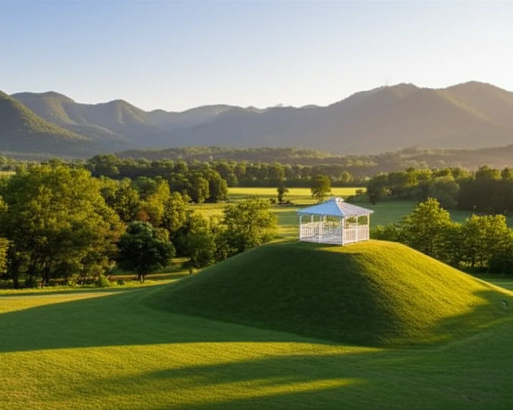
The Nacoochee Mound is the most visible and significant archaeological site in the Helen area. Located at the confluence of the Chattahoochee River and Dukes Creek, approximately two miles south of downtown Helen, this earthen mound rises from the center of the broad Nacoochee Valley. Topped by a white gazebo added in the 19th century by landowner Captain James Nichols, the mound is one of the most recognizable landmarks in north Georgia and represents the southernmost reach of the South Appalachian Mississippian cultural tradition.
The mound was constructed during the Mississippian period, roughly between 1000 and 1550 CE, by a culture that built ceremonial platform mounds, practiced intensive agriculture, and maintained complex social hierarchies. The Nacoochee Mound served as a platform for important structures - likely the residence of a chief or a ceremonial building - elevating them above the surrounding village as a symbol of authority and spiritual significance. Archaeological excavations conducted in the early 20th century by the Smithsonian Institution's Bureau of American Ethnology recovered numerous artifacts, including pottery, shell gorgets, copper ornaments, and human burials that confirmed the mound's ceremonial importance.
Today, the Nacoochee Mound is part of the Hardman Farm Historic Site, managed by Georgia State Parks. While climbing on the mound itself is prohibited to protect the archaeological integrity of the site, it is clearly visible from the pulloff on GA-17 and from the grounds of Hardman Farm. The setting is hauntingly beautiful - the ancient mound rising from the valley floor with the Blue Ridge Mountains forming a protective amphitheater in every direction.
Guaxule and the De Soto Expedition
The 1540 encounter that changed everything
In 1540, the Spanish explorer Hernando de Soto led his expedition through the southern Appalachians during his ill-fated quest for gold and a route to the Pacific. Historical accounts from the expedition describe a visit to a settlement called Guaxule, which many scholars believe was located in or near the Nacoochee Valley. De Soto's chroniclers described Guaxule as a prosperous settlement with a principal mound and surrounding village - a description that aligns with the archaeological evidence of the Nacoochee Mound and its associated community.
The encounter between De Soto's expedition and the people of Guaxule represents the first documented contact between European explorers and the indigenous inhabitants of what is now northeast Georgia. While the visit was brief, the long-term consequences were devastating. European diseases - smallpox, measles, influenza - for which indigenous populations had no immunity, spread rapidly through trade networks and decimated communities across the Southeast in the decades following contact. By the time English and Scots-Irish settlers arrived in the Georgia mountains in the 18th century, the great Mississippian chiefdoms had collapsed, and the Cherokee had emerged as the dominant cultural force in the region.
The Cherokee Nation
Civilization, sovereignty, and forced removal
By the 18th century, the Cherokee Nation controlled a vast territory spanning parts of eight present-day states, including virtually all of north Georgia. The Cherokee were among the most sophisticated indigenous civilizations in North America. Sequoyah's creation of the Cherokee syllabary in the 1820s gave the nation a written language. They established a constitutional government, published a bilingual newspaper (the Cherokee Phoenix), built schools and churches, and developed an agricultural economy that included plantations and livestock alongside traditional farming methods.
The Nacoochee Valley was firmly within Cherokee territory, and the name "Nacoochee" itself derives from the Cherokee word for the valley. Cherokee villages dotted the river valleys and mountain coves of the region, and the trails that became today's highways were originally Cherokee trading paths connecting communities across the mountains. The area around present-day Helen was used for hunting, fishing, and seasonal agriculture, taking advantage of the same natural abundance that had drawn human communities for thousands of years before.
The Trail of Tears
Forced removal and its lasting legacy
The discovery of gold at Dahlonega in 1828, just thirty-five miles from Helen, accelerated the pressure for Cherokee removal that had been building for decades. Despite their adoption of European-style governance, their written language, and their legal victories before the United States Supreme Court - including the landmark Worcester v. Georgia decision - the Cherokee were forcibly removed from their ancestral lands under the Indian Removal Act of 1830. Their capital at New Echota was abandoned, and the nation's government dissolved by force.
In 1838 and 1839, approximately 16,000 Cherokee were rounded up from their homes across the Southeast, including from the valleys and mountains around Helen, and forced to march westward to Indian Territory in present-day Oklahoma. The journey, known as the Trail of Tears, killed an estimated 4,000 Cherokee through exposure, disease, and starvation. The removal emptied the north Georgia mountains of their indigenous inhabitants and opened the land to European-American settlement - the beginning of the historical process that would eventually lead to the logging town, and later the Bavarian village, that occupies the valley today.
Acknowledging this history is an important part of understanding the landscape visitors enjoy today. The beauty of the Nacoochee Valley, the rivers, the mountain trails - all of these were home to a people who were displaced by force. The Nacoochee Mound is a quiet reminder of the thousands of years of indigenous civilization that came before, and visiting it with an awareness of that history changes how you see the region.
The 1915 Excavation
What the Smithsonian found beneath the mound
In 1915, the Smithsonian Institution's Bureau of American Ethnology conducted a formal excavation of the Nacoochee Mound that confirmed its significance as a major South Appalachian Mississippian site dating to the Lamar Period (approximately 1350-1600 AD). The excavation uncovered 75 human burials arranged in multiple layers, along with an extraordinary array of grave goods: copper celts traded from the Great Lakes region, intricately carved shell gorgets, conch shell drinking cups from the Gulf Coast, and finely crafted Lamar-style ceramics. These artifacts demonstrated that the Nacoochee Valley was not an isolated mountain community but a crossroads of trade and power, connected to networks that spanned the entire southeastern United States. Similar Mississippian mound complexes like the Etowah Indian Mounds near Cartersville illustrate the scale of this ancient civilization.
The mound had been modified before the Smithsonian arrived. Around 1890, Captain John Nichols, who owned the surrounding farmland, shaved off the top two feet of the mound to create a level platform for a Victorian gazebo. This well-intentioned but destructive act likely destroyed the most recent and best-preserved archaeological layer, removing artifacts and burials that could have provided crucial information about the mound's final period of use. The gazebo, rebuilt most recently in 2013, has since become inseparable from the mound's visual identity, creating the paradoxical image that graces postcards throughout the region: a charming white garden structure perched atop a centuries-old cemetery.
Continue Exploring
More history and stories from the region