The Nacoochee Valley: Ancient Mounds, Cherokee Heritage, and Georgia's Gold Rush Legacy
Your guide to the nacoochee valley: ancient mounds, cherokee heritage, and georgia's gold rush legacy in Helen, Georgia and the Blue Ridge Mountains
Introduction: A Valley Shaped by Centuries of History
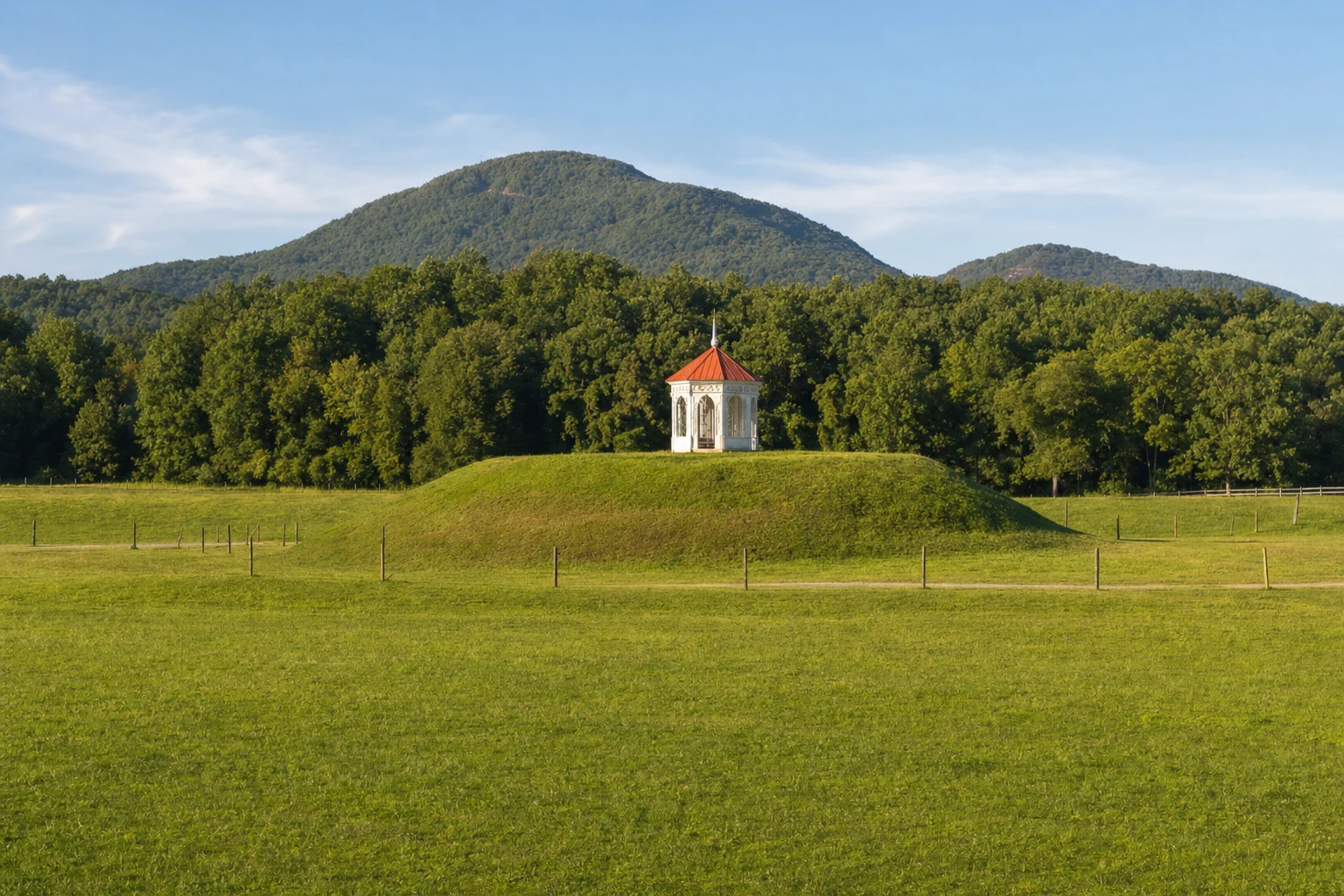
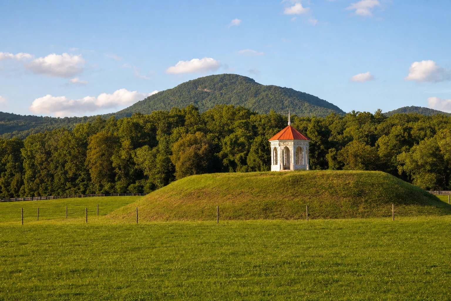
The Nacoochee Valley sits in the Blue Ridge Mountains just a few miles south of Helen, and it holds one of the longest human histories of any landscape in the Southeast. People have lived in this valley for thousands of years, from the Mississippian mound builders to the Cherokee, from Spanish explorers hunting for gold to the miners who tore up creek beds in the 1800s. The Nacoochee Indian Mound, with its white gazebo visible from the highway, is the most obvious reminder of all that history, but the whole valley is full of it.
The Nacoochee Valley experience offers modern visitors far more than a pleasant scenic drive through the mountains. It provides an opportunity to walk through genuine history, to understand the profound connections between landscape and human destiny, and to confront complex narratives of cultural flourishing and displacement that continue to echo through contemporary Georgia. This guide covers the valley's history from its earliest inhabitants through the gold rush era and offers practical details for visiting the most important sites.
The Nacoochee Indian Mound: An Ancient Ceremonial Center
Archaeological Origins and Mississippian Culture
The most iconic landmark of the Nacoochee Valley is the Nacoochee Indian Mound, a remarkable earthen platform mound located at the intersection of Georgia State Routes 75 and 17, approximately two miles south of downtown Helen. Far from being a recent construction, this mound represents nearly 1,500 years of continuous human habitation and cultural development.
The mound's earliest occupations date back to the Woodland culture period, between 100–500 CE. However, the distinctive platform mound structure that visitors see today - characterized by its flat-topped design - was constructed during the South Appalachian Mississippian period, specifically between 1350–1600 CE during the Lamar phase. This culture, a regional variation of the broader Mississippian civilization that flourished across much of the eastern United States, was responsible for building complex societies with hierarchical leadership structures, sophisticated agricultural systems, and extensive trade networks.
The Mississippian peoples who constructed the Nacoochee Mound were skilled farmers who took advantage of the valley's ideal growing conditions. The proximity to the Chattahoochee River, rich bottomland soils, and reliable water sources made the valley perfect for cultivating the "three sisters" - corn, beans, and squash - the agricultural foundation of Mississippian life. Archaeological evidence suggests the mound village was home to several hundred residents, with approximately 300 houses constructed on the flat lands surrounding the mound itself.
The 1915 Smithsonian Excavation
The most comprehensive historical documentation of the Nacoochee Mound comes from a professional archaeological excavation conducted between May and October 1915. This joint effort involved the Museum of the American Indian (Heyes Foundation) and the Bureau of American Ethnology of the Smithsonian Institution, making it one of the most thoroughly documented mound investigations of its era.
The excavation revealed 75 human burials, with artifacts indicating significant variations in social status among the deceased. High-status individuals were buried with distinctive grave goods including hammered copper celts, sheet copper ornaments, stone tools, conch shell beads, and decorated pottery vessels. Additionally, the archaeologists discovered artifacts indicating contact with European traders, including European glass beads, Spanish coins, and brass ornaments dating to the 17th century. These European artifacts suggest the site remained important even after European contact began.
The pottery sherds uncovered matched those found at the Etowah Indian Mounds near Cartersville, Georgia, providing archaeological confirmation that these two distant mound centers participated in the same cultural sphere and likely maintained trade relationships. Fire-pits were discovered at various levels within the mound, indicating it was used and modified repeatedly over generations. Some archaeologists note that the mound may have originally been even larger, as a 19th-century farmer reportedly lowered its height, likely destroying additional burials in the process.
From Mississippian to Cherokee Use
A fascinating aspect of Nacoochee's history involves its reuse by later peoples. While the Mississippian people who built the mound were gone by 1600, the site remained important to subsequent inhabitants. The Cherokee, who came to dominate the region, used the mound as a ceremonial center and townhouse site, although they did not construct it. Colonial records and 18th-century maps identified nearby Cherokee settlements known as Nacoochee and Chota, with historical markers describing the mound as the center of the "ancient Cherokee town of Guaxule."
However, modern scholarship disputes early claims that the Spanish explorer Hernando de Soto visited the mound during his 1540 expedition. While legends persist about de Soto's travels, topographic analysis and careful study of his chronicles suggest his actual route lay well to the west of the Nacoochee Valley.
Cherokee Heritage and the Unicoi Turnpike
The Cherokee Trading Path Network
Before European contact, the Nacoochee Valley was part of an extensive Cherokee trading path network that connected Overhill Cherokee settlements in present-day Tennessee to coastal ports at Savannah and Charleston. These paths existed for more than 1,000 years, long predating the Cherokee themselves - large mammals historically migrated along these routes during winter.
The most significant of these routes, the Unicoi Turnpike, crossed directly through the Nacoochee Valley. This path served multiple purposes: it was a sacred pilgrimage route, a vital trade artery for deerskins and furs, and a military corridor used during the French and Indian War and the American Revolution. In the Sautee-Nacoochee Valley, the turnpike connected to the broader Cherokee Trading Path network that extended to present-day Virginia, Pennsylvania, and Maryland.
The 1813 Treaty and Road Construction
In 1813, the Cherokee Nation granted permission to construct a formal toll road along the Unicoi Turnpike path. According to the treaty signed between Cherokee leaders and the U.S. government, the tribe would receive $160 annually for twenty years in exchange for road use rights. After the initial twenty years, the treaty stipulated that the agreement would either be renegotiated or the route would revert to Cherokee ownership. These payments, however, were reportedly never made.
The road was formally opened as the "Unaka Turnpike Road" by 1819, representing a major technological and commercial development for the region. The improved road enabled transportation of goods from northern Georgia and Tennessee to the port at Augusta, Georgia, allowing Tennessee farmers to access southern markets. By improving the route, however, the road also directly facilitated European American intrusion into Cherokee lands - ironically, the very threat the treaty was theoretically meant to address.
The Trail of Tears: A Dark Chapter
The shadow cast by removal and displacement looms large over the Nacoochee Valley's history. In 1838, the U.S. government forcibly removed more than 16,000 Cherokee people from their ancestral homelands in Alabama, Georgia, North Carolina, and Tennessee. This devastating forced march became known as the Trail of Tears - or in the Cherokee language, nu na da ul tsun yi, meaning "the place where they cried."
The Unicoi Turnpike became the first leg of this tragic journey for many Cherokee detainees. In June 1838, Captain L.B. Webster was ordered to move 800 Cherokee from Murphy, North Carolina over the Unicoi Turnpike through the Nacoochee Valley toward Fort Cass at Calhoun, Tennessee. Despite nearly thirty years of improvements, Webster famously described the road as "the worst I ever saw," noting that "it was pitiful to behold the women and children who suffered exceedingly as they were obliged to walk with the exception of the sick."
The journey was devastating. The 80-mile route took eight days of difficult travel through terrain now celebrated for its beauty. Across all removal routes, approximately 4,000 Cherokees died during the westward journey itself, with thousands more perishing in the years following relocation. The Helen to Hardman Heritage Trail, which now follows portions of the historic Unicoi Turnpike, offers visitors an opportunity to contemplate this history while enjoying scenic views of the Chattahoochee River.
The Georgia Gold Rush: Transformation and Extraction
Discovery and the "Great Intrusion"
The discovery of gold in the Nacoochee Valley marked a turning point in the region's history - one that would prove catastrophic for the Cherokee Nation. In 1828, gold was officially "rediscovered" in Dukes Creek within the Nacoochee Valley. A North Carolinian named John Witheroods found a three-ounce nugget there that year, and subsequent discoveries confirmed the presence of significant gold deposits.
The discovery's impact was amplified by media coverage. In August 1829, the Georgia Journal published notice of the gold finds, transforming local rumors into a full-blown rush. By autumn and winter of 1829, thousands of prospectors - derisively nicknamed the "Twenty-Niners" - had poured into the North Georgia mountains. By spring 1830, reports indicated 4,000 miners working on Yahoola Creek alone, demonstrating the scale of the migration. The Cherokee called this influx the "Great Intrusion."
Corporate Mining and Economic Displacement
The initial rush of individual placer miners - those panning gold from stream beds - was quickly supplanted by corporate operations. The best mining locations were rapidly consolidated by wealthy syndicates and partnerships founded by wealthy coastal planters. Senator John C. Calhoun emerged as one of the most significant mine operators in the region.
Paradoxically, many Cherokee found employment in these mining operations. The mining conglomerates commonly hired Cherokee as workers, particularly those who lived outside the official boundaries of Cherokee Nation territory and were therefore technically classified as Georgia citizens. This created a complex legacy: many contemporary residents of North Georgia who claim Cherokee ancestry are descended from these miners who worked the very lands from which their people were being extracted.
The Federal Mint and Lasting Economic Impact
The Georgia Gold Rush generated extraordinary wealth. During the 1828–1838 period, merchants in the Nacoochee and Dahlonega areas handled significant volumes of raw gold. In 1835, Congress authorized the establishment of a U.S. branch mint at Dahlonega, making it the first federal mint established outside the nation's capital. On April 17, 1838 - the very year of Cherokee removal - the first coins struck from Georgia gold left the Dahlonega mint and entered American commerce. This mint continued operating until 1861, producing $6 million in gold coins before the Civil War forced its closure.
Yet by the end of the 19th century, mining operations had largely ceased, and prospectors moved on to seek riches elsewhere. The England Gold Mine, located at the site of Helen's modern gold mine attraction, and Hamby Mountain had been extensively mined over the century, but deeper lode mining proved less profitable than the initial placer boom had promised.
Related Imagery from Around Helen