Track Rock Gap Archaeological Area: A Comprehensive Report on Cultural Heritage, Archaeological Significance, and Controversies
Your guide to track rock gap archaeological area: a comprehensive report on cultural heritage, archaeological significance, and controversies in Helen, Georgia and the Blue Ridge Mountains
Location and Status: Located in the Chattahoochee-Oconee National Forest near Blairsville, Georgia, Track Rock Gap (9UN367) is one of the most significant petroglyph sites in the Southeastern United States. However, access to the site has been severely restricted or closed as of 2024–2026 due to catastrophic vandalism and ongoing preservation efforts.
Archaeological Consensus: The site features soapstone boulders carved by Native American peoples, primarily ancestral Creek and Cherokee groups, dating from the Woodland to the Mississippian periods (c. 1000 AD) and potentially earlier. It is not a Mayan ruin; archaeological investigations have firmly debunked theories of Mesoamerican origin, attributing the site's sophisticated features to indigenous North American cultures.
Cultural Significance: To the Cherokee and Muscogee (Creek) peoples, the gap is a sacred threshold. Interpretations of the carvings range from records of a "Great Hunt" or the aftermath of a primordial flood to complex cosmological maps involving the "Spirit Folk" (Tsul 'kalu) and the interplay between the physical and spiritual worlds.
Key Points
Location and Status: Located in the Chattahoochee-Oconee National Forest near Blairsville, Georgia, Track Rock Gap (9UN367) is one of the most significant petroglyph sites in the Southeastern United States. However, access to the site has been severely restricted or closed as of 2024–2026 due to catastrophic vandalism and ongoing preservation efforts.
Archaeological Consensus: The site features soapstone boulders carved by Native American peoples, primarily ancestral Creek and Cherokee groups, dating from the Woodland to the Mississippian periods (c. 1000 AD) and potentially earlier. It is not a Mayan ruin; archaeological investigations have firmly debunked theories of Mesoamerican origin, attributing the site's sophisticated features to indigenous North American cultures.
Cultural Significance: To the Cherokee and Muscogee (Creek) peoples, the gap is a sacred threshold. Interpretations of the carvings range from records of a "Great Hunt" or the aftermath of a primordial flood to complex cosmological maps involving the "Spirit Folk" (Tsul 'kalu) and the interplay between the physical and spiritual worlds.
The Mayan Controversy: In 2011, a viral theory claimed the site was a Mayan city (Yupaha). This theory relies on misinterpretations of agricultural terraces and linguistic coincidences. It is rejected by professional archaeologists and Tribal Historic Preservation Officers as pseudo-archaeology that erases indigenous heritage.
1. Introduction and Geographical Context
The Track Rock Gap Archaeological Area is a 52-acre federally protected site located in Union County, Georgia, within the Blue Ridge Ranger District of the Chattahoochee-Oconee National Forest. Situated approximately 5 miles east of Blairsville and south of the Young Harris Highway (U.S. 76), the site lies in a low gap between Thunderstruck Mountain and Buzzard Roost Ridge. This geographical positioning is significant; in the mountainous topography of the Southern Appalachians, gaps served not only as physical transit routes for trade and hunting but also as metaphysical "thresholds" in indigenous cosmology.
The site is renowned for its petroglyphs - figures carved into soapstone (steatite) boulders. While the petroglyphs are the most visible feature, the archaeological zone also encompasses a complex series of stone piles, walls, and agricultural terraces on the surrounding ridges, which have become the subject of intense debate and misinterpretation in the 21st century.
1.1 Geology and Environment
The petroglyphs are carved into chlorite schist, commonly known as soapstone. This metamorphic rock is relatively soft, making it an ideal medium for carving, but also rendering it susceptible to erosion from acid rain, lichen growth, and human vandalism. The area is volcanic in origin, containing a dormant fumarole, which distinguishes its geology from the sedimentary formations found elsewhere in the Southeast.
2. The Petroglyphs: Description and Methodology
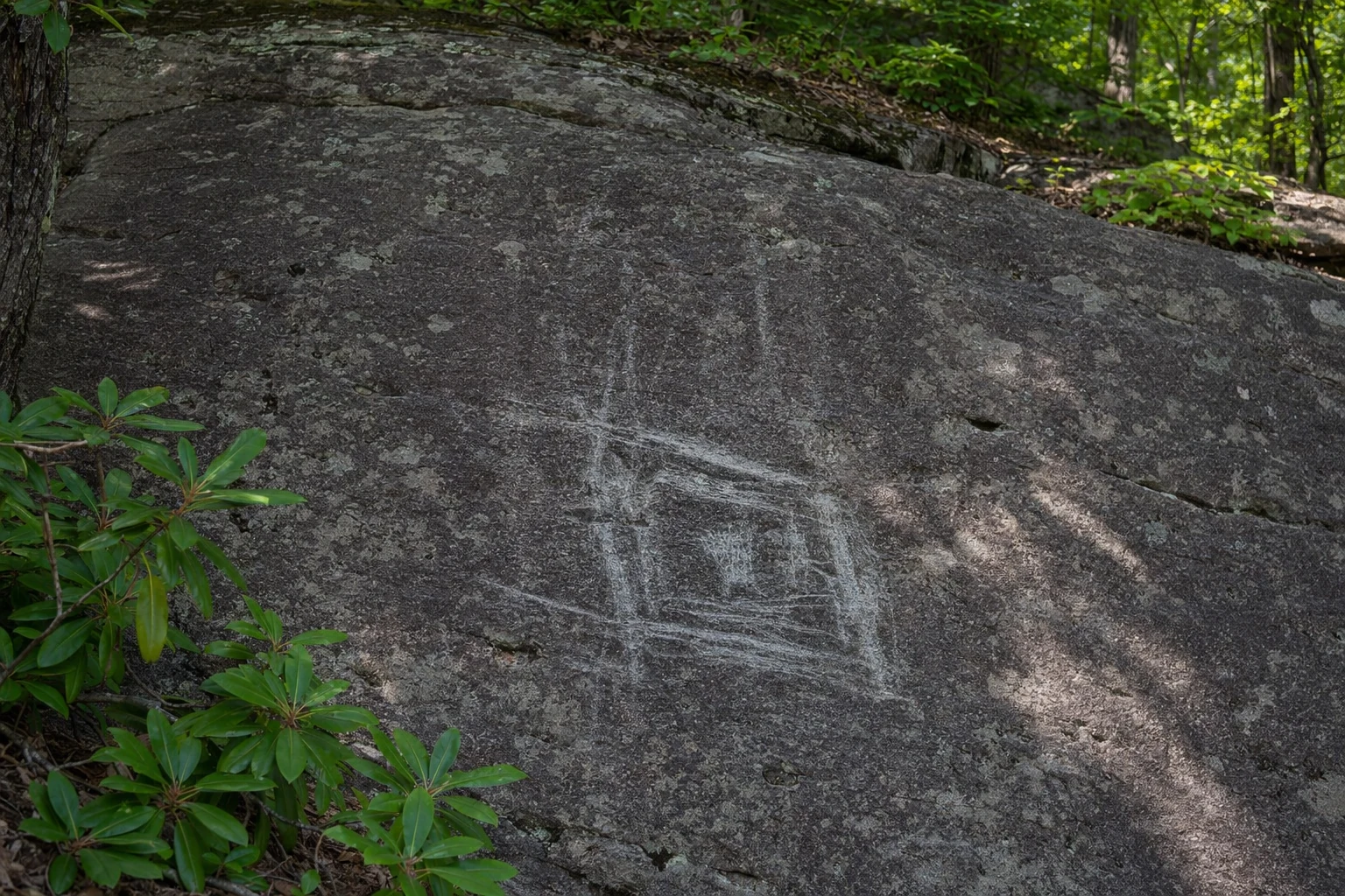
Track Rock Gap derives its name from the sheer density of carvings that resemble animal and human footprints. Early descriptions from the 19th century noted that the rocks appeared as if a multitude of creatures had walked over them while the stone was as soft as mud.
2.1 Motif Classification
The site contains six major table-sized boulders featuring hundreds of symbols. These motifs are generally classified into four categories:
Animal Tracks: Representations of bear, deer, turkey, and other bird tracks are prevalent. These are often realistic, suggesting intimate knowledge of local fauna.
Humanoid Forms: This includes human footprints (plantigrade tracks) and stick-figure human shapes.
Geometric Symbols: Circles, concentric rings, crosses (often enclosed in circles), grids, and curvilinear lines.
Cupules: Small, cup-shaped depressions pecked into the stone, which are common in rock art worldwide and often associated with ritual extraction of stone powder or marking specific events.
2.2 Creation Techniques
Archaeological analysis indicates the carvings were created using a "pecking" and "grinding" technique. Indigenous artisans used harder hammerstones (likely quartz or quartzite) to strike the soapstone surface, creating the initial shape, which was then smoothed or deepened through abrasion. The creation of these glyphs was not a singular event but a cumulative process occurring over centuries, likely beginning as early as the Late Archaic period (3,600 years ago) for soapstone bowl extraction, with the majority of the visible figurative art dating to the Late Woodland and Mississippian periods (c. 1000 AD – 1800 AD).
3. Cultural Interpretations and Oral History
The interpretation of Track Rock Gap is deeply rooted in the ethnohistory of the Cherokee (Ani-Yunwiya) and Muscogee (Creek) peoples. While Western archaeologists attempt to categorize the symbols, indigenous oral traditions provide the narrative context for the site's creation and function.
3.1 Cherokee Legends and James Mooney
In the late 19th century, ethnographer James Mooney recorded several Cherokee legends regarding the site. The Cherokee referred to the location as Datsu'nalasgun'ylu ("Where there are tracks") and Degayelun'ha ("The Printed Place").
The Great Canoe Legend: One prominent story posits that the tracks were made when a great flood nearly destroyed the world. As the animals disembarked from a "great canoe," the earth and rocks were still soft, capturing their footprints forever as the world hardened.
The Great Hunt: Another narrative suggests the glyphs were carved by hunters resting in the gap, recording a great hunt where animals were driven through the narrow pass.
The Spirit Folk (Tsul 'kalu): The site is often associated with Tsul 'kalu (Judaculla), the slant-eyed Master of Game and a giant spirit who dwells in the mountains. Similar to Judaculla Rock in North Carolina, Track Rock is viewed as a boundary marker or a record of the Spirit Folk's presence.
3.2 Cosmological Significance: The Threshold
Modern ethnohistorical analysis suggests the location of the petroglyphs - in a gap between mountain peaks - is intentional. In Cherokee cosmology, gaps represent liminal spaces or thresholds between the physical world and the spirit world. The footprint motifs may signify the movement of spirits (or the spirits of animals) transitioning between these realms. As noted by historians, the tracks act as "physical testimony that spirit beings were there... and that they could still be lingering somewhere close-by".
3.3 Muscogee (Creek) Connection
Before the Cherokee dominated the region in the 18th century, the area was inhabited by ancestors of the Muscogee Creek people, as confirmed by the Eastern Band of Cherokee Indians and tribal historians. Many scholars and tribal representatives assert that the site's origins lie with the Creek or a shared cultural tradition between the groups. The petroglyphs and nearby stone landscapes likely served ceremonial functions for these earlier inhabitants before becoming incorporated into Cherokee lore.
Related Imagery from Around Helen