Hiking and Driving the North Georgia Appalachian Trail: Woody Gap to Neels Gap
Your guide to hiking and driving the north georgia appalachian trail: woody gap to neels gap in Helen, Georgia and the Blue Ridge Mountains
The Woody Gap to Neels Gap section of the Appalachian Trail (AT) in North Georgia is one of the most popular day-hike and section-hike stretches on the entire 2,190-mile trail, and it earns that reputation. Covering approximately 10.8 miles of trail, this corridor traverses the Blood Mountain Wilderness, summits the highest peak on the Georgia AT, and concludes at the historic Walasi-Yi Interpretive Center - the only point where the trail passes through a man-made structure. For hikers, it is often the first major test of endurance; for motorists, the surrounding roadways offer a scenic loop known for its serpentine curves and vistas of the Blue Ridge.
This report provides an exhaustive analysis of the hiking and driving experience in this region, detailing the ecological hotspots for wildflowers, the architectural history of the Civilian Conservation Corps (CCC) structures, and the segment's enduring reputation as some of the finest miles on the Appalachian Trail.
Geography: The hiking segment runs northbound from Woody Gap (approx. Mile 20.5) to Neels Gap (Mile 31.3), featuring over 3,000 feet of elevation gain and loss, culminating at Blood Mountain (4,458 ft).
Key Points
The section of the Appalachian Trail (AT) spanning from Woody Gap to Neels Gap in North Georgia represents one of the most culturally significant, physically demanding, and visually spectacular segments of the entire 2,190-mile footpath. Covering approximately 10.8 miles of trail, this corridor traverses the Blood Mountain Wilderness, summits the highest peak on the Georgia AT, and concludes at the historic Walasi-Yi Interpretive Center - the only point where the trail passes through a man-made structure. For hikers, it is often the first major test of endurance; for motorists, the surrounding roadways offer a scenic loop known for its serpentine curves and vistas of the Blue Ridge.
This report provides an exhaustive analysis of the hiking and driving experience in this region, detailing the ecological hotspots for wildflowers, the architectural history of the Civilian Conservation Corps (CCC) structures, and the segment's enduring reputation as some of the finest miles on the Appalachian Trail.
Geography: The hiking segment runs northbound from Woody Gap (approx. Mile 20.5) to Neels Gap (Mile 31.3), featuring over 3,000 feet of elevation gain and loss, culminating at Blood Mountain (4,458 ft).
Scenic Highlights: Major overlooks include Preacher’s Rock (Big Cedar Mountain) and the rock outcrops atop Blood Mountain. Driving overlooks include Chestatee Overlook and the vistas from GA Hwy 60.
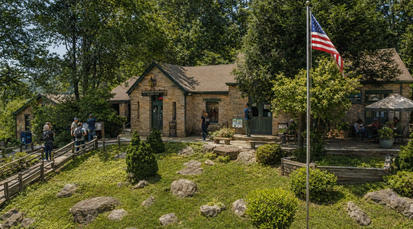
Mountain Crossings: Located at Neels Gap, the Walasi-Yi Center is a historic CCC structure serving as a hostel and outfitter. It is famously the only place where the AT passes through a building (a breezeway).
Wildflowers: The area is a botanical hotspot, particularly at Jarrard Gap and Sosebee Cove, featuring Trillium, Bloodroot, Flame Azalea, and rare cove hardwoods.
1. Topography and Trail Logistics
The traverse from Woody Gap to Neels Gap is a defining feature of the Southern Appalachians. The trail follows the Blue Ridge crest, acting as a watershed divide. This section is characterized by steep ascents, rocky terrain, and diverse forest ecologies ranging from mesic coves to high-elevation oak-hickory forests.
1.1 Distance and Elevation Profile
According to 2023 AT data, Woody Gap is located at Mile 20.5 (northbound from Springer Mountain), and Neels Gap is at Mile 31.3, making the section approximately 10.8 miles long.
Starting Elevation: Woody Gap (~3,164 ft).
Highest Point: Blood Mountain Summit (4,458 ft).
Ending Elevation: Neels Gap (~3,109 ft).
Total Elevation Change: Hikers experience approximately 3,000 feet of ascent and a similar amount of descent, heavily concentrated in the final approach and descent of Blood Mountain.
1.2 Access Points
Woody Gap: Located on GA Hwy 60. It features a paved parking lot, restrooms, and expansive views to the south even without hiking. It is a popular trailhead for day hikers and section hikers.
Neels Gap: Located on US Hwy 19/129. Parking is extremely limited at the Walasi-Yi Center itself (often restricted to customers). Hikers are encouraged to park at the Byron Reece Trailhead, located 0.5 miles north, to avoid congestion at the historic site.
2. The Hiking Experience: Woody Gap to Neels Gap
This 11-mile corridor is frequently cited as the most scenic and heavily trafficked section of the Georgia AT. It offers a microcosm of the Appalachian Trail experience: smooth dirt paths, root-gnarled climbs, rock scrambles, and panoramic vistas.
2.1 Woody Gap to Big Cedar Mountain (Preacher’s Rock)
Departing northbound from Woody Gap, the trail ascends gradually. The first major landmark, reached at approximately mile 1.0–1.2, is Preacher’s Rock (also known as Pulpit Rock).
The View: Preacher’s Rock is a broad, exposed granite outcrop on the southeast slope of Big Cedar Mountain. It offers unobstructed views of the rolling Piedmont and Dockery Lake below. Due to its accessibility and high reward-to-effort ratio, this is one of the most popular day-hiking destinations in Georgia.
Terrain: The ascent to Big Cedar Mountain (3,721 ft) involves switchbacks and an elevation gain of roughly 350 to 500 feet from the gap.
2.2 The Gaps: Miller, Jarrard, and Slaughter
Beyond Big Cedar Mountain, the trail undulates through a series of gaps that define the ridgeline approach to the Blood Mountain Wilderness.
Miller Gap: Offers seasonal views and campsites.
Jarrard Gap: Located roughly 5.7 to 6 miles from Woody Gap. This area is significant for its wildflowers (see Section 4) and serves as an intersection with the blue-blazed trail leading to Lake Winfield Scott.
Woods Hole Shelter: A side trail (0.4 miles) leads to this shelter, built in 1998. It is unique for its "Nantahala design" and honors Tillie and Roy Wood.
Slaughter Gap: At the base of Blood Mountain, this gap serves as a campsite area. Notably, fires are banned in the high-elevation zone from Slaughter Gap to Neels Gap to protect the fragile ecosystem and heavy usage areas.
2.3 The Ascent of Blood Mountain
Blood Mountain is the "crown jewel" of the Georgia AT. Standing at 4,458 feet, it is the highest point on the AT in Georgia and the sixth-tallest mountain in the state.
The Climb: The northbound ascent from Slaughter Gap involves a steady, strenuous climb through rocky switchbacks. The vegetation shifts to high-elevation stunted oaks and Catawba rhododendrons.
The Summit: The peak offers expansive rock outcrops providing 360-degree views. To the east, hikers can see Yonah Mountain and Tray Mountain; to the south, the Atlanta skyline is visible on clear days.
Byron Reece Trail: This blue-blazed trail intersects the AT near the summit and offers a shorter, steeper route for day hikers coming from the Neels Gap area.
2.4 The Descent to Neels Gap
The descent from Blood Mountain to Neels Gap is notorious for its steepness and technical difficulty. Hikers drop over 1,300 feet in approximately 2 miles. The trail is rugged, requiring careful footing over rock slabs and roots. This descent delivers hikers directly to the breezeway of the Mountain Crossings building.
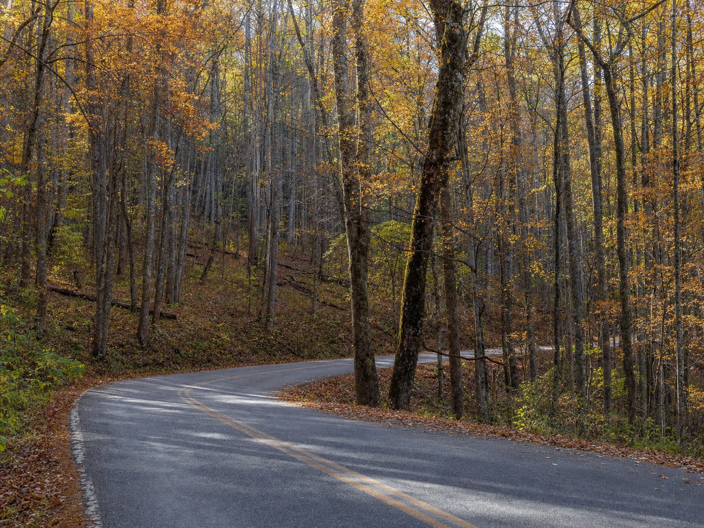
3. Scenic Driving Tour: The Suches Loop
For those who prefer four wheels to two feet, the drive connecting Woody Gap and Neels Gap is part of a celebrated route often called the "Suches Loop" or the "Georgia Dragon" due to its twisting pavement and elevation changes.
Related Imagery from Around Helen