The Highland Crown: A Comprehensive Guide to North Georgia Scenic Drives
The Russell-Brasstown Scenic Byway, Richard Russell Highway, and mountain roads winding through the Blue Ridge
Key Points
The Russell-Brasstown Scenic Byway: This 40.6-mile loop is the premier driving route in the region, encompassing GA-348, GA-180, and GA-75/17. It circumnavigates the headwaters of the Chattahoochee River and offers high-elevation vistas.
Historical Significance: Many of these routes, particularly GA-180 and the infrastructure at Vogel State Park, were developed by the Civilian Conservation Corps (CCC) in the 1930s. GA-197 served as a historic moonshine route during Prohibition.
Driving Difficulty: Drivers should be prepared for steep grades and sharp switchbacks, particularly on Wolf Pen Gap Road (GA-180) and the approach to Bell Mountain. These routes are favored by motorcyclists and sports car enthusiasts but require caution during inclement weather.
Ecological Diversity: The routes provide access to unique ecosystems, such as the high-elevation north-facing cove forest at Sosebee Cove and the rugged granite domes of the Raven Cliffs Wilderness.
Introduction
The North Georgia mountains are the southern end of the Blue Ridge range -- rolling peaks, deep hardwood forests, and layers of Cherokee and Appalachian history visible at every turn. For anyone who enjoys driving, this region has some of the best mountain roads in the southeastern United States, twisting through the Chattahoochee-Oconee National Forest and connecting Alpine villages to quiet farming valleys.
Below are the most significant scenic drives in the region, with the specific details you need to actually drive them -- elevations, mileages, key stops, and contact information for the attractions along the way.
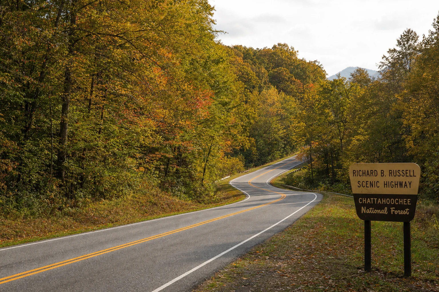
1. Richard B. Russell Scenic Highway (GA-348)
Route Overview: Completed in 1967 and named for the late U.S. Senator Richard B. Russell, this 14-mile corridor cuts directly through the wild heart of the Blue Ridge, connecting Helen (via GA-75 Alt) to the Choestoe area south of Blairsville. It is widely considered the most visually spectacular stretch of pavement in the state, climbing from the valleys to cross the Appalachian Trail at high gaps.
Key Stops and Overlooks
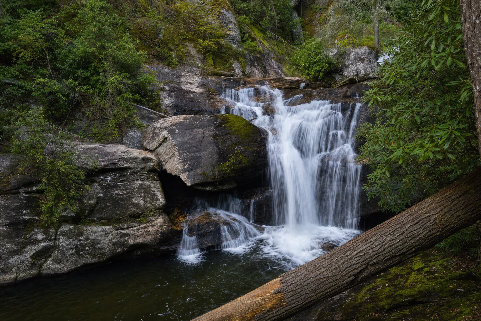
Dukes Creek Falls Recreation Area
Location: ~1.5 miles north of the southern terminus of GA-348.
GPS Coordinates: 34.702063, -83.789413.
Description: This site offers a moderate hiking trail leading to viewing platforms of the 150-foot multi-tiered falls located at the convergence of Davis and Dukes Creeks.
Trail Data: 1.25 miles one-way (2.5 miles round-trip). The trail descends from the parking lot, making the return trip an uphill hike.
Fees: $4.00 per vehicle day-use fee (Credit card machine or Recreation.gov QR code onsite).
2. Wolf Pen Gap Road (GA-180)
Route Overview: Often called "The Dragon’s Tail of Georgia," GA-180 runs east-west, connecting US-19/129 at Vogel State Park to GA-60 in Suches. This road is legendary among motorcyclists for its technical difficulty, featuring tight switchbacks and limited sightlines.
Scenic & Historical Highlights
Vogel State Park
Address: 405 Vogel State Park Dr, Blairsville, GA 30512.
Phone: (706) 745-2628.
History: One of Georgia's oldest state parks, established in 1931 with major infrastructure built by the Civilian Conservation Corps (CCC).
Key Feature: Lake Trahlyta. A relatively flat 1-mile loop trail circles the 22-acre lake, including a spur trail to the Trahlyta Falls spillway.
Fees: $5.00 parking pass.
3. The Blood Mountain Loop (US-19/129) & Neels Gap
Route Overview: This major artery connects Cleveland/Turner’s Corner to Blairsville, crossing the Blue Ridge at Neels Gap. It is the most trafficked route over the mountains and rich in Appalachian Trail culture.
Major Stops
Mountain Crossings at Walasi-Yi Center (Neels Gap)
Address: 12471 Gainesville Hwy, Blairsville, GA 30512.
Phone: (706) 745-6095.
Hours: Daily 9:00 AM – 5:00 PM.
Elevation: 3,125 feet.
Significance: Completed in 1937 by the CCC, this stone building is the only covered point where the Appalachian Trail passes directly through a man-made structure. It serves as a hostel, outfitter, and resupply point for thru-hikers.
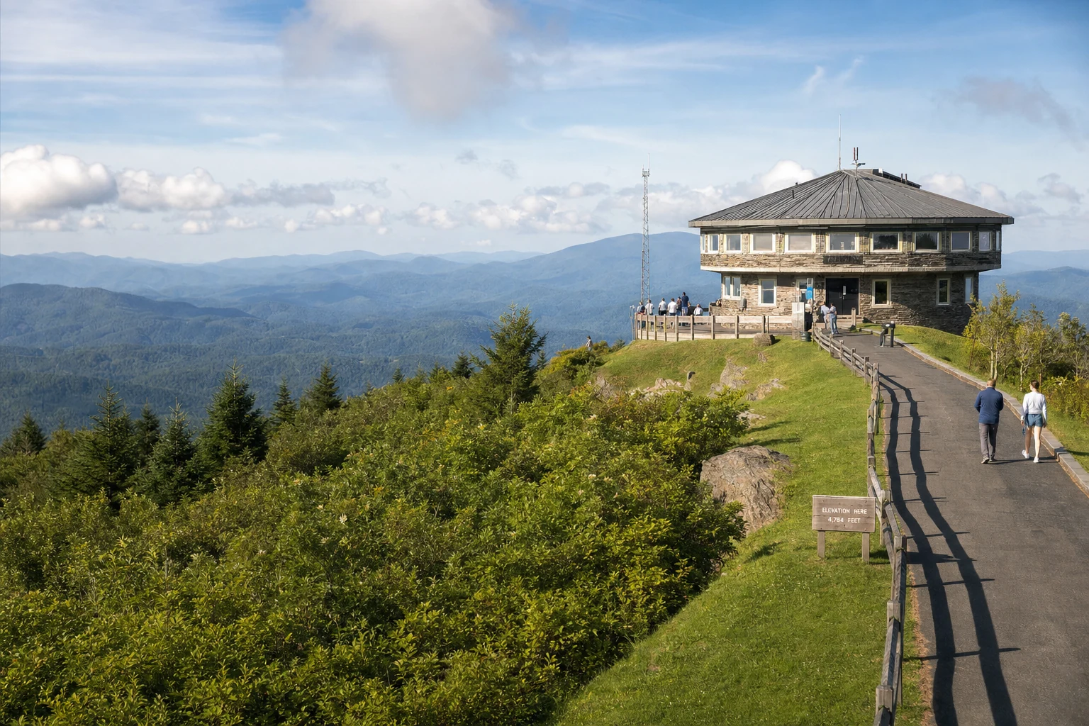
4. Brasstown Bald Road (GA-180 Spur)
Route Overview: Branching off GA-180, this steep spur leads to the rooftop of Georgia. This route is part of the Russell-Brasstown Scenic Byway.
Brasstown Bald Visitor Center & Recreation Area
Location: 2941 Hwy 180 Spur, Hiawassee, GA 30546.
Phone: (706) 896-2556.
Elevation: 4,784 feet (Highest point in Georgia).
Hours of Operation: Daily 10:00 AM – 5:00 PM (Weather permitting; road often closes in winter due to ice).
5. GA-75 (Helen to Hiawassee)
Route Overview: Following the path of the historic Unicoi Turnpike, this road climbs out of the tourist hub of Helen, crosses Unicoi Gap, and descends into the Hiawassee Valley.
Unicoi Gap
Elevation: 2,949 feet.
Coordinates: 34.8009 N, 83.7429 W.
Recreation: A large parking area marks where the AT crosses the highway. Hikers can trek north toward Tray Mountain or south toward Blue Mountain.
High Shoals Falls Scenic Area
Related Imagery from Around Helen