Timbers of Time: An Exhaustive Guide to the Covered Bridges of North and Central Georgia
Stovall Mill, Poole's Mill, and Georgia's surviving wooden covered bridges with driving directions
Key Points
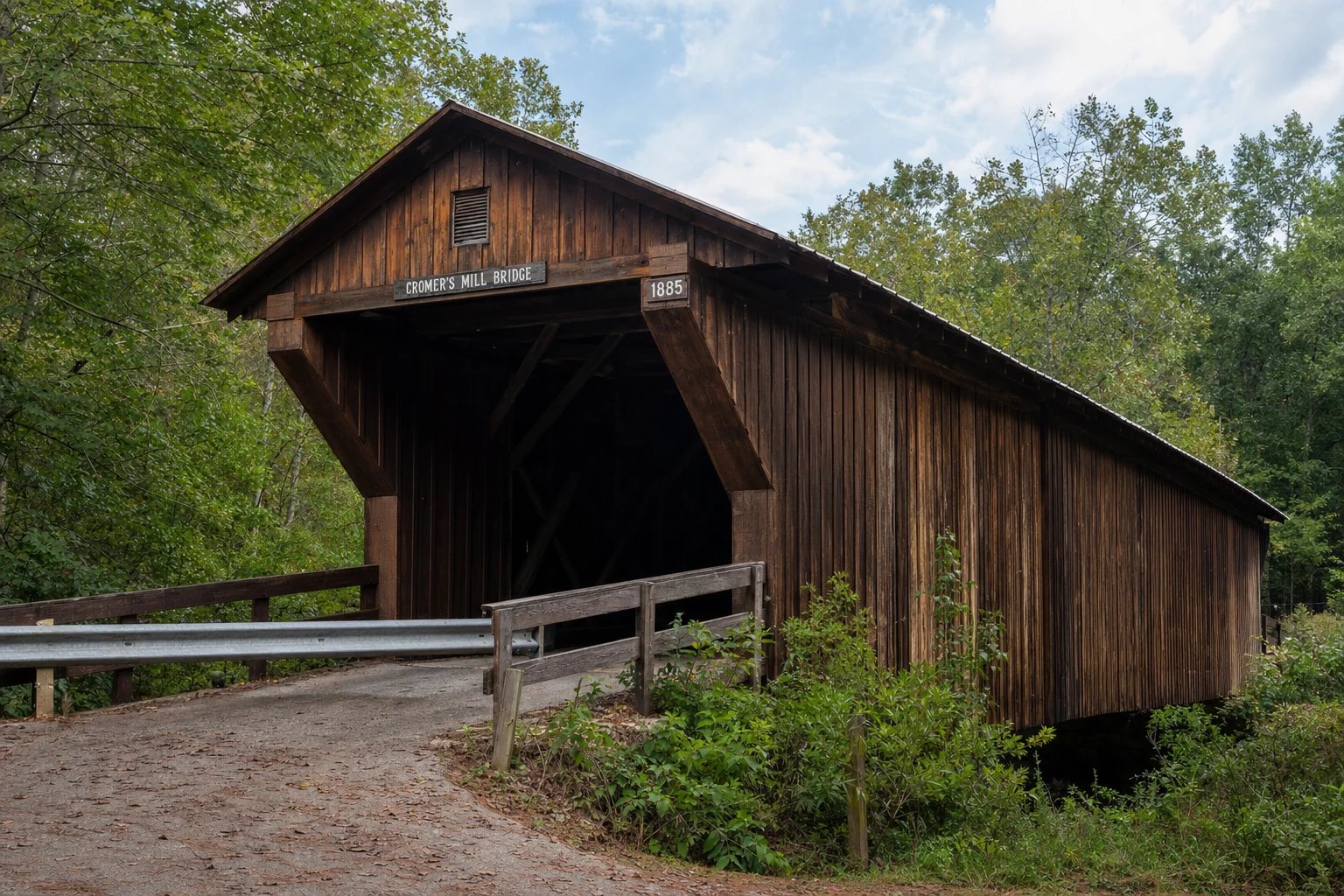
Historical Rarity: Georgia once had over 250 covered bridges, many documented by the Georgia Historical Society; today, fewer than 20 remain, with the specific bridges in this guide representing some of the finest preserved examples of 19th-century engineering.
Geographical Clarification: While the Stovall Mill Bridge is firmly in the North Georgia mountains (White County), Poole’s Mill is in the distinct foothills of Forsyth County. Elder Mill serves the Oconee piedmont, and Auchumpkee Creek requires a journey into Central Georgia (Upson County). This guide bridges these distances into a cohesive historic narrative.
Introduction: The Vanishing Tunnels of Georgia
In the late 19th century, the Georgia landscape was stitched together by more than 250 covered bridges, wooden tunnels that spanned the rushing creeks of the Appalachians and the languid rivers of the Piedmont. Known colloquially as "kissing bridges" for the privacy they afforded courting couples, or "tunnels across the creek," these structures were practical necessities born of ingenuity. Covering the bridge was not for aesthetics, but for preservation; without a roof to protect the massive heart-pine timbers from rain and rot, a wooden bridge might last only a decade. Covered, they could stand for centuries.
Today, fewer than 20 of these historic structures remain in Georgia. For the discerning traveler, they offer more than a photo opportunity; they are tactile connections to a time when travel was measured in the clip-clop of hooves rather than highway miles. This guide focuses on a curated selection of these survivors: the cinematic Stovall Mill Bridge in the Alpine Helen area, the park-centric Poole's Mill Bridge, the drivable Elder Mill Bridge, and the resilient Auchumpkee Creek Bridge. While clustered under the umbrella of "North Georgia" tourism, traversing them all requires a commitment to the backroads, taking you from the Blue Ridge foothills down to the central heartland of the state.
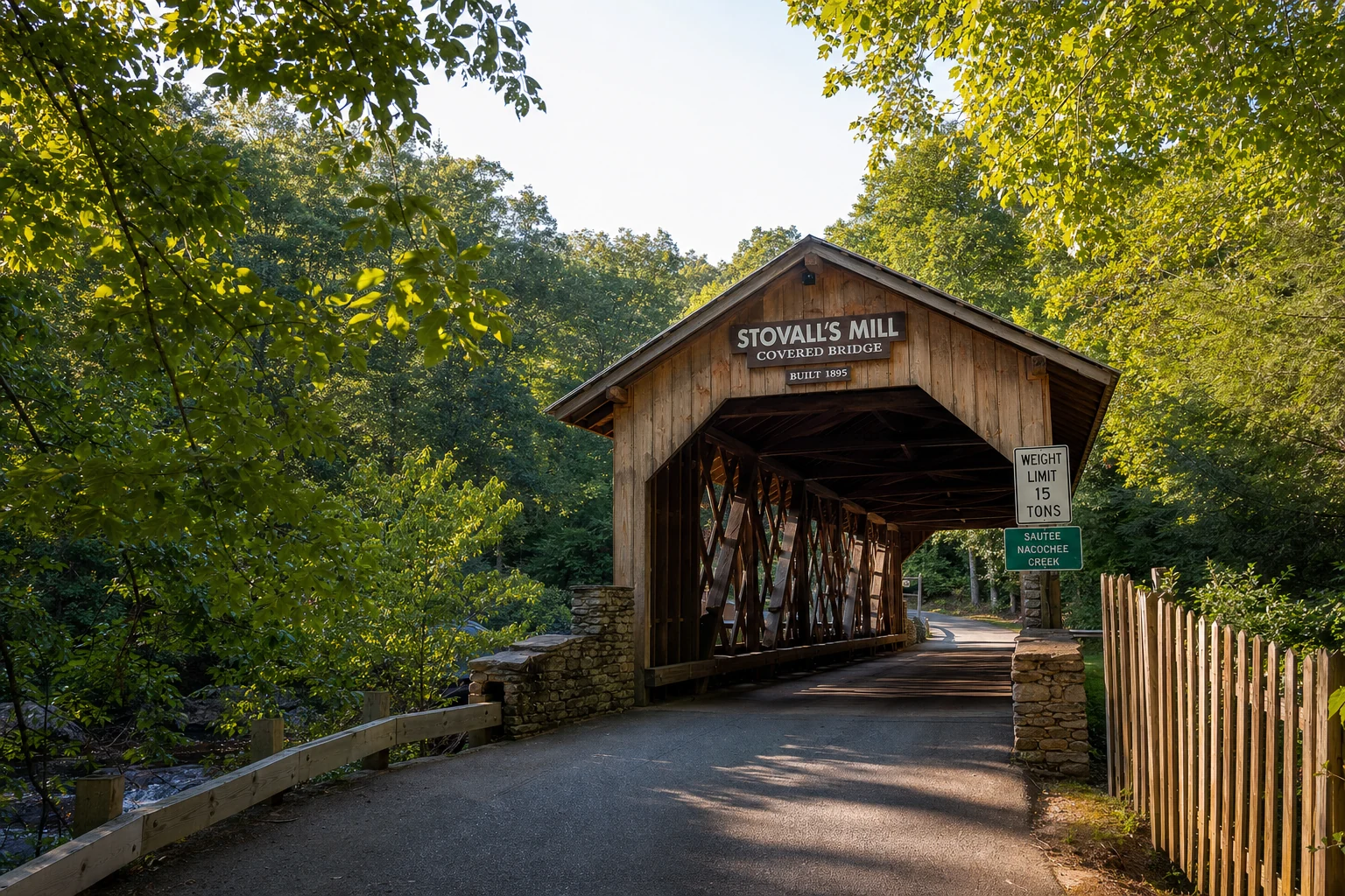
1. Stovall Mill Covered Bridge
The Cinematic Miniature of the Mountains
Located in the shadow of Mount Yonah and just a short drive from the Bavarian-themed village of Alpine Helen, the Stovall Mill Covered Bridge is a crown jewel of White County. It holds the distinction of being the shortest clear-span covered bridge in Georgia and is listed on the National Register of Historic Places, a small but solid piece of mountain craftsmanship.
Historical Provenance
The current structure, spanning Chickamauga Creek, was erected in 1895 by builder Will Pardue. It replaced an earlier bridge that was washed away by a flood in the early 1890s. The site was originally the epicenter of a complex owned by Fred Dover, which included a grist mill, saw mill, and shingle mill driven by a water turbine. In 1917, the operation was sold to Fred Stovall, Sr., lending the bridge its current name. While the mill and dam were destroyed in 1964, the bridge survived.
Culturally, this bridge is royalty. It was featured prominently in the 1951 film I'd Climb the Highest Mountain, starring Susan Hayward and William Lundigan, cementing its status as a local icon.
Architectural & Site Specifications
Truss Design: King-post truss (some sources describe it as a modified Queen-post with vertical posts and iron rods).
Length: Approximately 33 to 38 feet.
Span: One lane wide; restricted to pedestrian traffic only.
Waterway: Spans Chickamauga Creek.
Elevation: Located in the Sautee Nacoochee Valley, approximately 1,300–1,400 feet above sea level (based on regional topography).
Visitor Information
Address: GA Hwy 255, Sautee Nacoochee, GA 30571. (Specifically, ~3 miles north of the Old Sautee Store).
GPS Coordinates: Latitude: 34.711011 | Longitude: -83.675063.
Admission: Free.
Hours: Open daylight hours, year-round.
Parking: There are gravel pull-offs on both sides of the road near the bridge.
The Tourist Experience
Stovall Mill Bridge is not just a static monument. It is a beloved local swimming hole. Beneath the bridge, Chickamauga Creek pools around large shoals, creating a refreshing dip for summer visitors. The interior of the bridge, though historically significant, is heavily marked with graffiti - modern "petroglyphs" of lovers' initials that some find charming and others find vandalistic. Picnic tables are available on the banks, making it an ideal lunch stop.
Photography Tip: The best angle is from the creek bank looking upward to capture the stone abutments and the rush of water beneath the timber floor. Early morning fog often settles in the Nacoochee Valley, providing a moody, ethereal atmosphere for photographers.
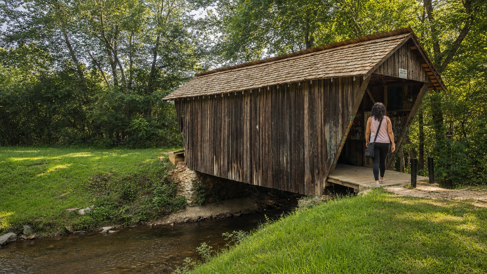
2. Poole's Mill Covered Bridge
The Forsyth County Park Jewel
Correction Note: While the user query associated this bridge with White County, Poole's Mill Covered Bridge is located in Forsyth County, near Cumming and Ball Ground. It sits roughly 45 miles southwest of Helen, making it a distinct leg of the journey.
Historical Provenance
The history of this site dates back to c. 1820, when Cherokee Chief George Welch constructed a gristmill and a sawmill here. Following the Cherokee Removal (Trail of Tears) in 1838, the land passed to Jacob Scudder and later, in 1880, to Dr. M.L. Pool.
The current bridge was built in 1901. Its construction is the stuff of local legend. The contract was initially given to a builder named John Wofford. Wofford reportedly drilled the holes for the lattice pegs in the wrong locations. Upon realizing his error - and perhaps overwhelmed by the precision required - he abandoned the project (some accounts suggest he left town after consuming a gallon of corn whiskey). The bridge was completed by Bud Gentry, who had to redrill the holes. Visitors with a keen eye can still spot the misplaced holes in the timbers today.
Architectural & Site Specifications
Truss Design: Town Lattice truss.
Length: 96 feet.
Waterway: Spans Settendown Creek.
Restoration: The bridge collapsed/sagged significantly in the 1980s/90s. It was restored in 1997, with a support pier added in the middle of the creek for stability.
Visitor Information
Location: Poole's Mill Park.
Address: 7725 Poole's Mill Road, Ball Ground, GA 30107.
GPS Coordinates: N34 17.459 W84 14.555.
Admission: Free.
Hours:
March – October: 6:00 AM – 9:30 PM
Related Imagery from Around Helen