Tallulah Gorge
Your guide to tallulah gorge in Helen, Georgia and the Blue Ridge Mountains
Introduction to Tallulah Gorge State Park
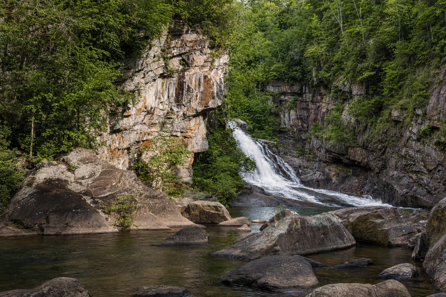
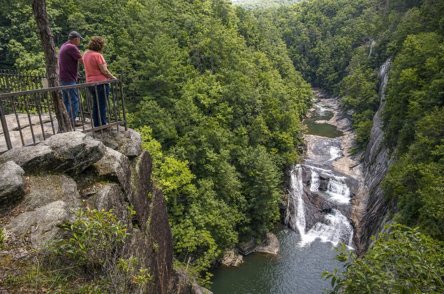
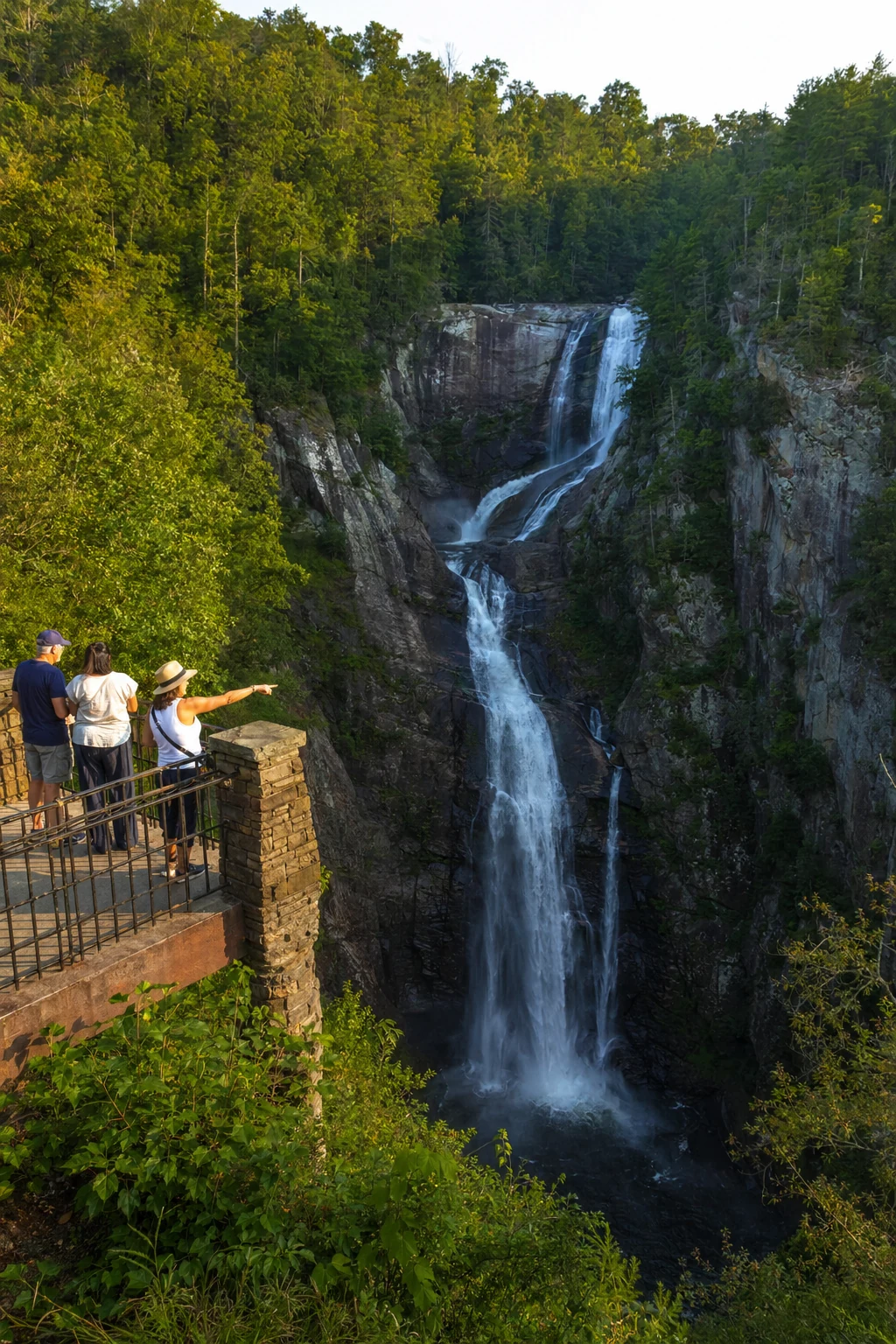
Tallulah Gorge State Park is one of the deepest gorges east of the Mississippi River. The Tallulah River has carved a 2-mile-long, nearly 1,000-foot-deep canyon through the North Georgia mountains, with six waterfalls dropping the river 500 feet over one mile. The 2,689-acre park sits at 338 Jane Hurt Yarn Rd, Tallulah Falls, GA 30573, along the Rabun-Habersham county line, about 30 miles south of Helen. You can walk the rim trails for easy overlook views, or grab one of the 100 free daily permits for the strenuous gorge floor hike. The suspension bridge sways under your feet, and the sound of Hurricane Falls fills the canyon. It is one of the most powerful natural places in North Georgia.
Historical Context
Tallulah Gorge has drawn visitors since the 19th century, with tourism booming after the 1882 completion of the Tallulah Falls Railroad, which ferried thousands weekly to this Victorian resort area, spurring nearly 20 hotels and attractions like horseback riding in the unincorporated town that incorporated as Tallulah Falls in 1885. Efforts to protect the gorge intensified in the early 1900s amid Georgia Power's hydroelectric dam construction; in 1911, Helen Dortch Longstreet, widow of Confederate General James Longstreet, led the Tallulah Falls Conservation Association to temporarily halt a dam, though power companies prevailed via Supreme Court appeal (with Georgia Power eventually building the hydroelectric facilities), altering the river's flow.
The modern state park formed through 1992 cooperation between Georgia Power and the state, officially establishing Tallulah Gorge State Park in 1993 under Governor Zell Miller on 2,710 acres, preserving the gorge below Tallulah Falls Dam while highlighting its geologic and ecological significance, including rare species like persistent trillium and green salamanders. Today, visitors can see Karl Wallenda's tightrope towers from his daring 1970s crossings, blending history with adventure.
Getting There and Practical Logistics
Location and Contact
The park sits near the Chattahoochee National Forest and is reachable via US Hwy 441/23 from Helen, about 30 to 45 minutes south. GPS coordinates are 34.739750, -83.395233. Call (706) 754-7981 or visit gastateparks.org/TallulahGorge for current conditions. The Jane Hurt Yarn Interpretive Center is open daily from 8 AM to 5 PM.
Fees and Hours
Park hours are 8 AM to 5 PM daily, year-round, with a $5 daily parking fee per vehicle (Georgia State Parks annual pass covers it); gorge floor permits are free but limited - grab them at the Interpretive Center after safety briefings at 8 AM, 10 AM, and 12 PM (first-come, first-served, often gone by mid-morning on weekends). No reservations for day permits; groups over 20-30 have restrictions.
Parking and Accessibility
Multiple lots offer handicap-accessible spots near the visitor center and rims; the main lot slopes slightly but is smooth asphalt, leading to ramps and a recycled rubber trail to Overlooks 1A, 2, and 3 - ideal for wheelchairs or strollers. EV chargers are available; arrive early (before 9 AM weekends) as lots fill fast, especially for permits. Leashed pets are okay on rims but banned on gorge floor/Sliding Rock; no flip-flops/Crocs required for floor hikes.
What to Bring
Pack sturdy closed-toe shoes for 1,000+ strenuous stairs, water (no fountains on floor), snacks, rain gear (rocks slippery when wet), bug spray, sunscreen, and layers - temps drop in the gorge. Bring binoculars for waterfalls, a picnic for shelters, and download offline maps; check ahead for water releases closing floor access.
Hiking Trails and Main Attractions
Rim Trails: Panoramic Views Without Permits
The park has over 20 miles of trails. The North and South Rim Trails (easy to moderate, 1-3 miles roundtrip) pass six overlooks with views of the gorge's sheer cliffs and six waterfalls: Oceana, Tempest, Trip, Amicolah, Hurricane, and Bridal Veil. The 80-foot-high suspension bridge crosses mid-gorge and gives you a perspective you will not forget. North Rim Overlook 1 has the best framed view of Hurricane Falls. The 1.7-mile paved Rails-to-Trails path along the old railroad bed works well for bikes and strollers.
Gorge Floor Adventure: Permit-Required Thrill
The Gorge Floor Trail is the big draw. You descend 600-plus stairs to reach Hurricane Falls, then follow rocky paths past Oceana and Bridal Veil Falls. Bridal Veil has a natural rock slide, but be careful of strong currents. The full strenuous loop via Sliding Rock runs 3 to 4 miles. You need a permit, proper closed-toe shoes, and decent fitness. It is not suitable for children under 8. The boulders at the bottom are smooth from millennia of water, and the sound of the falls echoing off the canyon walls is something else. You cannot pass Bridal Veil; from there, climb the Sliding Rock Trail back to the South Rim.
Other Activities
Swim seasonally at the 63-acre lake beach, fish, play tennis, or rock climb (free permit 8 AM-2 PM, closed Feb-mid March for falcons). Mountain biking on 10-mile loops; interpretive films at the center detail ecology.
Seasonal Considerations and Best Times to Visit
Spring (March-May) bursts with wildflowers, mild 50-70°F temps, and fewer crowds - perfect for hiking, though watch for rain. Fall (Sep-Nov) dazzles with fiery foliage, cooler 50-70°F days, but gorge floor closes for aesthetic/whitewater releases (e.g., 2026: April 4-5,11-12 whitewater 500-700 CFS; April/May aesthetic 200 CFS) - rims stay open for epic leaf-peeping.
Summer (Jun-Aug) suits swimming but brings 80-90°F humidity, crowds, thunderstorms - early mornings best. Winter (Dec-Feb) offers misty, icy waterfalls (trails may ice over, floor risky), fewer visitors, 30-50°F - stunning solitude if prepared. Peak avoids July-Aug heat; check gastateparks.org for releases closing floor (call ahead). From Helen base, fall pairs gorge hikes with Oktoberfest vibes.
Related Imagery from Around Helen